• Skip to main content
  • Skip to secondary menu
  • Skip to primary sidebar
  • Skip to secondary sidebar
  • Skip to footer
  • DroneRacingLife
  • DroneFlyers
  • Newsletter
DroneLife

DRONELIFE

Stay up to date on all the latest Drone News

  • News
  • Products
  • Industries
    • Agriculture
    • Construction
    • Delivery
    • Dual Use
    • Inspection
    • Public Safety
    • Surveying
  • Enthusiasts
  • Regulations
  • Business
  • Video
  • Podcasts

GeoCue Expands TrueView Lineup with TV1 and TV1 Lite: Affordable, High-Performance LiDAR for Drone Surveys

February 17, 2025 by Miriam McNabb Leave a Comment

New survey-grade sensors offer precision mapping at accessible price points, bringing professional LiDAR technology to a wider audience.

by DRONELIFE Staff Writer Ian J. McNabb

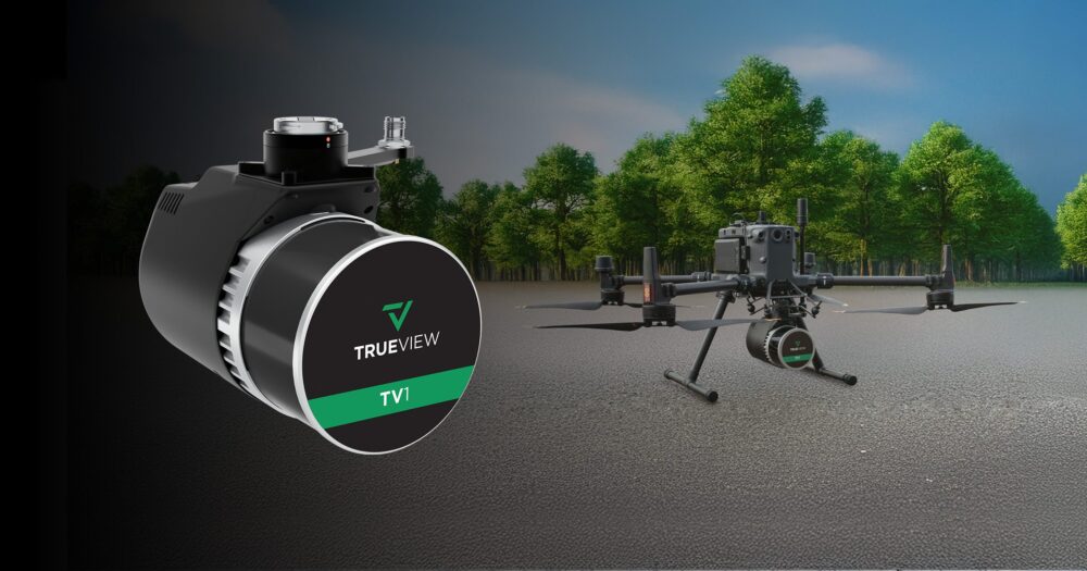
Alabama-based LiDAR (Light Detection and Ranging) technology developer GeoCue announced their newest additions to their TrueView lineup of sensors- the TV1 and the TV1 Lite. These new, survey-grade geospatial sensors are designed for accuracy and affordability, bringing high-performance drone survey technology to a wider audience.

The TrueView 1 Lite, GeoCue’s most accessible LiDAR sensor yet, is “designed to bring survey-grade accuracy to all.” At a price point of $18,990, customers receive the TrueView 1 Lite along with a full year of TV1 Lite Annual Processing, including a comprehensive support and maintenance plan. After the first year, users can take advantage of convenient annual renewal. This performance is powered by the innovative TrueNav, with a proven Hesai, 32 channels laser scanner, and a FLIR 5MP Global Shutter Camera with a 90º FOV. 

“The TV1 Lite makes cutting edge LiDAR technology available for almost everyone,” said Frank Darmayan, CEO of GeoCue. “We’re committed to expanding professional LiDAR solutions that are not only advanced but also attainable, ensuring every professional can leverage the power of precise data collection. This is the ultimate starter solution for anyone looking to step into the world of precise mapping without the high cost.”

For users who need even more flexibility, the TrueView 1 offers customizable options starting with a choice of a 26 MP, 45 MP, or 61 MP camera. You can then choose the Trajectory Correction Service with either the Single Base processing Option, for PPK, or the Complete/No Base Station processing option, with Trimble PP-RTX unlimited trajectory processing (which can help mitigate errors involved with the use of a base station. Included in the annual plan is LP360 Drone software processing, along with ongoing maintenance and support.

“The TrueView 1 affords you the flexibility to create the system best suited for your work. By adding these new options to our product line, we are expanding our LiDAR footprint and demonstrating that TrueView systems offer a complete solution, from hardware to software, including data collection and deliverable creation. This is a testament to our commitment to providing not just tools, but solutions that include support and training to ensure success for our users,” said Vivien Heriard Dubreuil, CEO of GeoCue’s France-based parent company, mdGroup.

More information about GeoCue and the TrueView lineup is available here

Want DRONELIFE news delivered to your inbox every weekday?  Sign up here.

Read more:

  • GeoCue and Clogworks Technologies Announce Partnership to Expand LiDAR Drone Mapping Solutions
  • GeoCue and CHC Navigation Unveil TrueView 540: LiDAR Innovation
  • GeoCue Partners with Tediris to Integrate TrueView 3D Imaging with Aero 4 Drone


Miriam McNabb

Miriam McNabb is the Editor-in-Chief of DRONELIFE and CEO of JobForDrones, a professional drone services marketplace, and a fascinated observer of the emerging drone industry and the regulatory environment for drones. Miriam has penned over 3,000 articles focused on the commercial drone space and is an international speaker and recognized figure in the industry.  Miriam has a degree from the University of Chicago and over 20 years of experience in high tech sales and marketing for new technologies.
For drone industry consulting or writing, Email Miriam.

TWITTER:@spaldingbarker

Subscribe to DroneLife here.

Filed Under: Applications, Drone News, Drone News Feeds, News Tagged With: aerial surveying, drone mapping, drone surveying, GeoCue, geospatial technology, LiDAR sensor, Mapping solutions, survey-grade LiDAR, TrueView 1, TrueView 1 Lite

Reader Interactions

Leave a Reply Cancel reply

Your email address will not be published. Required fields are marked *

Primary Sidebar

LATEST

DroneDeploy Launches Progress AI to Automate Construction Tracking

New AI tool delivers accurate jobsite updates in minutes, saving time and reducing risk DroneDeploy Introduces AI-Powered Construction Progress Tool…

Continue Reading DroneDeploy Launches Progress AI to Automate Construction Tracking

Hands-On Learning, Public Safety Take Center Stage at Commercial UAV Expo 2025

Partnerships with Pilot Institute and AIRT Bring Comprehensive Training for Drone Pilots and First Responders The Commercial UAV Expo 2025…

Continue Reading Hands-On Learning, Public Safety Take Center Stage at Commercial UAV Expo 2025

Blueflite Drones to Deliver Auto Parts in Detroit

Michigan-Backed Pilot Project Aims to Modernize Automotive Logistics with Aerial Delivery A New Era of Auto Parts Delivery In a…

Continue Reading Blueflite Drones to Deliver Auto Parts in Detroit

Amprius Delivers Next-Gen SiCore® Batteries to Leading Drone Manufacturers

High-energy cells support long-endurance UAV missions for Airbus subsidiary AALTO and others Amprius Expands Drone Battery Shipments from Fremont Pilot…

Continue Reading Amprius Delivers Next-Gen SiCore® Batteries to Leading Drone Manufacturers

Solid State Batteries: A Disruptive Force in the Commercial and Dual-Use Drone Market

Battery Endurance: The Persistent Drone Challenge Battery life has long stood as a defining constraint in commercial and dual-use drone…

Continue Reading Solid State Batteries: A Disruptive Force in the Commercial and Dual-Use Drone Market

Drones Join the Front Lines in Deadly Texas Flood Response

Group deploys drones to search for victims in Texas Hill Country flood By DRONELIFE Features Editor Jim Magill The deadly…

Continue Reading Drones Join the Front Lines in Deadly Texas Flood Response

Tethered and Unstoppable: How Fiber-Optic Drones Are Rewriting the Rules of Battlefield Control

As radio-controlled drones face growing interference, Ukraine and Russia embrace fiber-optic UAVs for unjammable, high-precision operations. What Is a Fiber-Optic…

Continue Reading Tethered and Unstoppable: How Fiber-Optic Drones Are Rewriting the Rules of Battlefield Control

U.S. Drone Industry Investment Surges Amid Sweeping Legislative Reforms

The drone industry in the United States is experiencing a surge in investment and capital flow, as a series of…

Continue Reading U.S. Drone Industry Investment Surges Amid Sweeping Legislative Reforms

US and Ukraine Move Closer to Landmark Drone Deal

Big Plans for Drone Collaboration The United States and Ukraine are in advanced talks over a new partnership that could…

Continue Reading US and Ukraine Move Closer to Landmark Drone Deal

High Lander Launches Vega HighSite for Local Airspace Management

New solution enables safe and scalable drone operations for commercial and government sites High Lander Aviation has introduced Vega HighSite,…

Continue Reading High Lander Launches Vega HighSite for Local Airspace Management

Secondary Sidebar

Footer

SPONSORED

Inspired Flight Gremsy IF800 VIO F1 drones geo week

What Will It Take to Strengthen U.S. Drone Manufacturing? A Conversation with Inspired Flight’s CEO

Global Mapper Mobile data collection

Collection Ground Control Points with Global Mapper Mobile

Military Drone Mapping Solutions

How SimActive’s Correlator3D™ is Revolutionizing Military Mapping: An Exclusive Interview with CEO Philippe Simard

Photogrammetry Accuracy Standards

SimActive Photogrammetry Software: Enabling Users to Meet Accuracy Standards for Over 20 Years

NACT Engineering Parrot ANAFI tether indoor shot

Smart Tether for Parrot ANAFI USA from NACT Engineering

Blue Marble, features global mapper, features Blue Marble

Check Out These New Features in Global Mapper v25 from Blue Marble

About Us | Contact Us | Advertise With Us | Write for Us | Privacy Policy | Terms of Service

The Trusted Source for the Business of Drones.

This website uses cookies and third party services. By clicking OK, you are agreeing to our privacy policy. ACCEPT

Manage consent

Privacy Overview

This website uses cookies to improve your experience while you navigate through the website. Out of these, the cookies that are categorized as necessary are stored on your browser as they are essential for the working of basic functionalities of the website. We also use third-party cookies that help us analyze and understand how you use this website. These cookies will be stored in your browser only with your consent. You also have the option to opt-out of these cookies. But opting out of some of these cookies may affect your browsing experience.
Necessary
Always Enabled
Necessary cookies are absolutely essential for the website to function properly. These cookies ensure basic functionalities and security features of the website, anonymously.
CookieDurationDescription
cookielawinfo-checkbox-analytics11 monthsThis cookie is set by GDPR Cookie Consent plugin. The cookie is used to store the user consent for the cookies in the category "Analytics".
cookielawinfo-checkbox-functional11 monthsThe cookie is set by GDPR cookie consent to record the user consent for the cookies in the category "Functional".
cookielawinfo-checkbox-necessary11 monthsThis cookie is set by GDPR Cookie Consent plugin. The cookies is used to store the user consent for the cookies in the category "Necessary".
cookielawinfo-checkbox-others11 monthsThis cookie is set by GDPR Cookie Consent plugin. The cookie is used to store the user consent for the cookies in the category "Other.
cookielawinfo-checkbox-performance11 monthsThis cookie is set by GDPR Cookie Consent plugin. The cookie is used to store the user consent for the cookies in the category "Performance".
viewed_cookie_policy11 monthsThe cookie is set by the GDPR Cookie Consent plugin and is used to store whether or not user has consented to the use of cookies. It does not store any personal data.
Functional
Functional cookies help to perform certain functionalities like sharing the content of the website on social media platforms, collect feedbacks, and other third-party features.
Performance
Performance cookies are used to understand and analyze the key performance indexes of the website which helps in delivering a better user experience for the visitors.
Analytics
Analytical cookies are used to understand how visitors interact with the website. These cookies help provide information on metrics the number of visitors, bounce rate, traffic source, etc.
Advertisement
Advertisement cookies are used to provide visitors with relevant ads and marketing campaigns. These cookies track visitors across websites and collect information to provide customized ads.
Others
Other uncategorized cookies are those that are being analyzed and have not been classified into a category as yet.
SAVE & ACCEPT