
RedEdge-P camera to be integrated with Spirit UAV, expanding U.S. drone capabilities for precision agriculture At AUVSI XPONENTIAL 2025, Ascent AeroSystems and AgEagle announced a strategic collaboration to integrate the RedEdge-P™ multispectral camera with Ascent’s rugged Spirit™ UAV. This partnership reflects the growing expansion of options in the U.S.-manufactured drone … [Read more...] about Ascent AeroSystems and AgEagle Partner to Deliver Advanced Agricultural Drone Solution
multispectral imaging
Drone Mapping is Getting Bigger and Better: SimActive’s Philippe Simard Talks Industry Trends

Philippe Simard, of Canada's SimActive mapping software, started out working directly with large mapping companies - or the military. With the growth of the drone industry, however, things have changed. “We used to only work with very highly qualified firms investing millions of dollars in planes – I can still remember the point at which those clients came to us … [Read more...] about Drone Mapping is Getting Bigger and Better: SimActive’s Philippe Simard Talks Industry Trends
Multispectral Imaging Processing Expands Drone Applications in Agriculture and More for SimActive
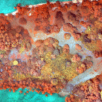
Data gathered from sophisticated sensors requires sophisticated processing. Now, SimActive Inc., a leading developer of photogrammetry software, has announces the release of Correlator3D™ version 8.2 - which provides advanced processing capabilities of multispectral imagery. Correlator3D's new version registers multispectral as well as infrared images automatically, and the … [Read more...] about Multispectral Imaging Processing Expands Drone Applications in Agriculture and More for SimActive


