
The new platform offers faster workflows, safer urban operations, and broad payload flexibility for surveyors worldwide. Wingtra's new drone, WingtraRAY, designed to push the limits of aerial surveying and mapping. The WingtraRAY is built specifically for surveyors and promises to remove many of the operational barriers they face today. One major highlight is its ability to … [Read more...] about Wingtra Unveils WingtraRAY: A New Drone to Transform Aerial Surveying
aerial surveying
Enhancing Drone Mapping with RTK and PPK: Insights from SimActive’s Eric Andelin

Drone mapping technology has advanced significantly in recent years, with Real-Time Kinematic (RTK) and Post-Processed Kinematic (PPK) positioning emerging as game-changing technologies. These methods enhance mapping accuracy and efficiency, reducing reliance on traditional Ground Control Points (GCPs). SimActive, a leading provider of photogrammetry software, offers powerful … [Read more...] about Enhancing Drone Mapping with RTK and PPK: Insights from SimActive’s Eric Andelin
GeoCue Expands TrueView Lineup with TV1 and TV1 Lite: Affordable, High-Performance LiDAR for Drone Surveys

New survey-grade sensors offer precision mapping at accessible price points, bringing professional LiDAR technology to a wider audience. by DRONELIFE Staff Writer Ian J. McNabb Alabama-based LiDAR (Light Detection and Ranging) technology developer GeoCue announced their newest additions to their TrueView lineup of sensors- the TV1 and the TV1 Lite. These new, survey-grade … [Read more...] about GeoCue Expands TrueView Lineup with TV1 and TV1 Lite: Affordable, High-Performance LiDAR for Drone Surveys
GeoCue and Clogworks Technologies Announce Partnership to Expand LiDAR Drone Mapping Solutions
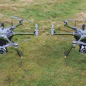
New Collaboration Enhances Aerial Surveying Capabilities with Integrated LiDAR and Software Solutions GeoCue has announced a new partnership with UK-based drone manufacturer Clogworks Technologies Limited. This collaboration integrates GeoCue’s TrueView LiDAR and LP360 software with Clogworks’ Dark Matter series of UAVs. The partnership aims to provide surveyors and mapping … [Read more...] about GeoCue and Clogworks Technologies Announce Partnership to Expand LiDAR Drone Mapping Solutions
Event 38 Unmanned Systems Incorporates Advanced LiDAR Technology into E455 Drone
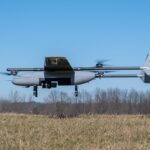
Event 38 Unmanned Systems Integrates Advanced LiDAR onto E455 Drone Event 38 Unmanned Systems, a global leader in the manufacturing of unmanned aerial vehicles, has announced a significant upgrade to their Heavy VTOL E455 Drone. The drone can now be equipped with multiple LiDAR systems, including the Resepi Hesai LIDAR XT-32 developed by Inertial Labs. The integration of … [Read more...] about Event 38 Unmanned Systems Incorporates Advanced LiDAR Technology into E455 Drone


