
Advanced photogrammetry software supports rapid delivery of high-quality geospatial products SimActive Inc., a global developer of photogrammetry software, has announced that SurvTech Solutions is using its Correlator3D product to process large-scale image datasets from drones and large-format cameras. The software enables SurvTech to deliver digital surface models and … [Read more...] about SimActive’s Correlator3D Speeds Up Processing of Large Drone Datasets for SurvTech
geospatial data
SimActive Releases Correlator3D Version 10.4 with Enhanced 3D Model Controls
New Update Offers Greater Flexibility for Photogrammetry and LiDAR Workflows SimActive Inc., a leading developer of photogrammetry software, has released Version 10.4 of its Correlator3D platform. This new version gives users more control over 3D model creation, with advanced tools for both photogrammetry and LiDAR data. Full Control for Diverse Workflows Correlator3D … [Read more...] about SimActive Releases Correlator3D Version 10.4 with Enhanced 3D Model Controls
Enhancing Drone Mapping with RTK and PPK: Insights from SimActive’s Eric Andelin

Drone mapping technology has advanced significantly in recent years, with Real-Time Kinematic (RTK) and Post-Processed Kinematic (PPK) positioning emerging as game-changing technologies. These methods enhance mapping accuracy and efficiency, reducing reliance on traditional Ground Control Points (GCPs). SimActive, a leading provider of photogrammetry software, offers powerful … [Read more...] about Enhancing Drone Mapping with RTK and PPK: Insights from SimActive’s Eric Andelin
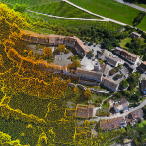
SimActive and Air Data Solutions Enhance Oil & Gas Mapping with High-Resolution Aerial Imagery

Correlator3D and Phase One Cameras Support Large-Scale Mapping Operations SimActive Inc.’s Correlator3D software is being used by Air Data Solutions (ADS) to map large oil and gas operations in South Texas. By integrating Phase One camera systems, ADS captures thousands of high-resolution images annually to produce detailed digital maps. Streamlining Aerial Mapping with … [Read more...] about SimActive and Air Data Solutions Enhance Oil & Gas Mapping with High-Resolution Aerial Imagery
Mastering Drone Mapping: Expert Tips for Success from SimActive’s Eric Andelin
SimActive and Correlator3D™: A Closer Look Drone mapping has transformed industries by making geospatial data more accessible. However, achieving high-quality results requires both the right tools and the right approach. DRONELIFE.com interviewed Eric Andelin, Senior Workflow Specialist at SimActive, to uncover actionable tips for drone operators. SimActive, a leader in … [Read more...] about Mastering Drone Mapping: Expert Tips for Success from SimActive’s Eric Andelin


