• Skip to main content
  • Skip to secondary menu
  • Skip to primary sidebar
  • Skip to secondary sidebar
  • Skip to footer
  • DroneRacingLife
  • DroneFlyers
  • Newsletter
DroneLife

DRONELIFE

Stay up to date on all the latest Drone News

  • News
  • Products
  • Industries
    • Agriculture
    • Construction
    • Delivery
    • Dual Use
    • Inspection
    • Public Safety
    • Surveying
  • Enthusiasts
  • Regulations
  • Business
  • Video
  • Podcasts

ROCK Robotic Releases New LiDAR Systems for Advanced, Survey-Grade Mapping

April 21, 2023 by Miriam McNabb 5 Comments

ROCK LiDAR
 

ROCK Robotic Launches R3 and R3 PRO LiDAR Mapping Systems

by DRONELIFE Staff Writer Ian M. Crosby

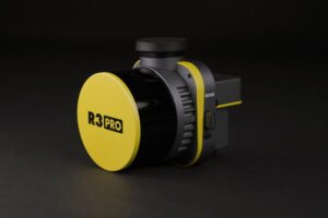
ROCK Robotic, a developer of professional survey-grade LiDAR technology, has announced the launch of the R3 and R3 PRO systems, its latest in LiDAR mapping solutions. The R3 product line incorporates advanced hardware components within a lightweight, integrated 3D point cloud collection tool. The R3 is an intuitive, end-to-end LiDAR solution that will integrate into ROCK Robotic’s comprehensive LiDAR approach.

“The ROCK R3 PRO is a major step forward for ROCK Robotic,” said ROCK Robotic CEO Harrison Knoll. “It offers better accuracy, better SLAM, a better camera, a lighter payload — basically a better product all around. Not only will our current customers love it, but we’re confident that the R3 will attract new customers who want a great hardware product along with our great software and support.”

The ROCK R3 line features state-of-the-art technology such as a geodetic-grade GNSS receiver and tactical-grade IMU. The device comes equipped with a detachable 26MP camera for high-resolution RGB image capture. The R3 employs a Hesai Pandar XT16 sensor, while the R3 PRO offers the superior Hesai Pandar XT32 sensor. The solution weighs only 1.26 kg (2.77 lb) compared to its predecessor, the ROCK 360 system’s 1.70 kg (3.74 lb). The R3 also provides optional advanced SLAM capabilities for mapping on the ground and in areas with weak GNSS signals.

“We want surveyors and mapping professionals to have the simplest workflow while getting the best results and deliverables,” said Knoll. “From the time you’re out in the field flying your drone to when you send deliverables to your client, ROCK makes it as easy as possible to make it happen. With the recently released ROCK Desktop software, R3 system and ROCK Cloud post-processing software, we’ve got all the bases covered. ROCK is definitely stepping up as a major player in the LiDAR arena.”

Read more:

  • Colorizing Lidar: SimActive and LiDARUSA Partner
  • Choosing a LiDAR Sensor: What They Are, What They Do
  • Draganfly Launches New Products: Two New Aircraft, and Long Range LiDAR [DRONELIFE Interviews CEO Cameron Chell]
  • For the Dark, Dirty and Dangerous, Flyability Elios 3 LiDAR Drone: Check Out this Fly Through a Decommissioned Nuclear Plant
  • Censys Adds LiDAR Options to Long-Range, BVLOS Fixed Wing

Ian attended Dominican University of California, where he received a BA in English in 2019. With a lifelong passion for writing and storytelling and a keen interest in technology, he is now contributing to DroneLife as a staff writer.


Miriam McNabb

Miriam McNabb is the Editor-in-Chief of DRONELIFE and CEO of JobForDrones, a professional drone services marketplace, and a fascinated observer of the emerging drone industry and the regulatory environment for drones. Miriam has penned over 3,000 articles focused on the commercial drone space and is an international speaker and recognized figure in the industry.  Miriam has a degree from the University of Chicago and over 20 years of experience in high tech sales and marketing for new technologies.
For drone industry consulting or writing, Email Miriam.

TWITTER:@spaldingbarker

Subscribe to DroneLife here.

Filed Under: Drone News, Drone News Feeds, Drones in the News, News

Reader Interactions

Trackbacks

  1. ROCK LiDAR Systems for Survey-Grade Mapping says:
    April 22, 2023 at 12:19 am

    […] More… […]

    Reply
  2. ROCK LiDAR Systems for Survey-Grade Mapping - Fantastin says:
    April 21, 2023 at 10:30 pm

    […] Source link […]

    Reply
  3. ROCK LiDAR Systems for Survey-Grade Mapping – Game Up News says:
    April 21, 2023 at 5:15 pm

    […] Source link […]

    Reply
  4. ROCK Robotic Releases New LiDAR Systems for Advanced, Survey-Grade Mapping - UAV FL says:
    April 21, 2023 at 1:08 pm

    […] post ROCK Robotic Releases New LiDAR Systems for Advanced, Survey-Grade Mapping appeared first on […]

    Reply
  5. ROCK Robotic Releases New LiDAR Systems for Advanced, Survey-Grade Mapping | taktik(z) GDI (Government Defense Infrastructure) says:
    April 21, 2023 at 12:51 pm

    […] post ROCK Robotic Releases New LiDAR Systems for Advanced, Survey-Grade Mapping appeared first on […]

    Reply

Leave a Reply Cancel reply

Your email address will not be published. Required fields are marked *

Primary Sidebar

LATEST

DroneDeploy Launches Progress AI to Automate Construction Tracking

New AI tool delivers accurate jobsite updates in minutes, saving time and reducing risk DroneDeploy Introduces AI-Powered Construction Progress Tool…

Continue Reading DroneDeploy Launches Progress AI to Automate Construction Tracking

Hands-On Learning, Public Safety Take Center Stage at Commercial UAV Expo 2025

Partnerships with Pilot Institute and AIRT Bring Comprehensive Training for Drone Pilots and First Responders The Commercial UAV Expo 2025…

Continue Reading Hands-On Learning, Public Safety Take Center Stage at Commercial UAV Expo 2025

Blueflite Drones to Deliver Auto Parts in Detroit

Michigan-Backed Pilot Project Aims to Modernize Automotive Logistics with Aerial Delivery A New Era of Auto Parts Delivery In a…

Continue Reading Blueflite Drones to Deliver Auto Parts in Detroit

Amprius Delivers Next-Gen SiCore® Batteries to Leading Drone Manufacturers

High-energy cells support long-endurance UAV missions for Airbus subsidiary AALTO and others Amprius Expands Drone Battery Shipments from Fremont Pilot…

Continue Reading Amprius Delivers Next-Gen SiCore® Batteries to Leading Drone Manufacturers

Solid State Batteries: A Disruptive Force in the Commercial and Dual-Use Drone Market

Battery Endurance: The Persistent Drone Challenge Battery life has long stood as a defining constraint in commercial and dual-use drone…

Continue Reading Solid State Batteries: A Disruptive Force in the Commercial and Dual-Use Drone Market

Drones Join the Front Lines in Deadly Texas Flood Response

Group deploys drones to search for victims in Texas Hill Country flood By DRONELIFE Features Editor Jim Magill The deadly…

Continue Reading Drones Join the Front Lines in Deadly Texas Flood Response

Tethered and Unstoppable: How Fiber-Optic Drones Are Rewriting the Rules of Battlefield Control

As radio-controlled drones face growing interference, Ukraine and Russia embrace fiber-optic UAVs for unjammable, high-precision operations. What Is a Fiber-Optic…

Continue Reading Tethered and Unstoppable: How Fiber-Optic Drones Are Rewriting the Rules of Battlefield Control

U.S. Drone Industry Investment Surges Amid Sweeping Legislative Reforms

The drone industry in the United States is experiencing a surge in investment and capital flow, as a series of…

Continue Reading U.S. Drone Industry Investment Surges Amid Sweeping Legislative Reforms

US and Ukraine Move Closer to Landmark Drone Deal

Big Plans for Drone Collaboration The United States and Ukraine are in advanced talks over a new partnership that could…

Continue Reading US and Ukraine Move Closer to Landmark Drone Deal

High Lander Launches Vega HighSite for Local Airspace Management

New solution enables safe and scalable drone operations for commercial and government sites High Lander Aviation has introduced Vega HighSite,…

Continue Reading High Lander Launches Vega HighSite for Local Airspace Management

Secondary Sidebar

Footer

SPONSORED

Inspired Flight Gremsy IF800 VIO F1 drones geo week

What Will It Take to Strengthen U.S. Drone Manufacturing? A Conversation with Inspired Flight’s CEO

Global Mapper Mobile data collection

Collection Ground Control Points with Global Mapper Mobile

Military Drone Mapping Solutions

How SimActive’s Correlator3D™ is Revolutionizing Military Mapping: An Exclusive Interview with CEO Philippe Simard

Photogrammetry Accuracy Standards

SimActive Photogrammetry Software: Enabling Users to Meet Accuracy Standards for Over 20 Years

NACT Engineering Parrot ANAFI tether indoor shot

Smart Tether for Parrot ANAFI USA from NACT Engineering

Blue Marble, features global mapper, features Blue Marble

Check Out These New Features in Global Mapper v25 from Blue Marble

About Us | Contact Us | Advertise With Us | Write for Us | Privacy Policy | Terms of Service

The Trusted Source for the Business of Drones.

This website uses cookies and third party services. By clicking OK, you are agreeing to our privacy policy. ACCEPT

Manage consent

Privacy Overview

This website uses cookies to improve your experience while you navigate through the website. Out of these, the cookies that are categorized as necessary are stored on your browser as they are essential for the working of basic functionalities of the website. We also use third-party cookies that help us analyze and understand how you use this website. These cookies will be stored in your browser only with your consent. You also have the option to opt-out of these cookies. But opting out of some of these cookies may affect your browsing experience.
Necessary
Always Enabled
Necessary cookies are absolutely essential for the website to function properly. These cookies ensure basic functionalities and security features of the website, anonymously.
CookieDurationDescription
cookielawinfo-checkbox-analytics11 monthsThis cookie is set by GDPR Cookie Consent plugin. The cookie is used to store the user consent for the cookies in the category "Analytics".
cookielawinfo-checkbox-functional11 monthsThe cookie is set by GDPR cookie consent to record the user consent for the cookies in the category "Functional".
cookielawinfo-checkbox-necessary11 monthsThis cookie is set by GDPR Cookie Consent plugin. The cookies is used to store the user consent for the cookies in the category "Necessary".
cookielawinfo-checkbox-others11 monthsThis cookie is set by GDPR Cookie Consent plugin. The cookie is used to store the user consent for the cookies in the category "Other.
cookielawinfo-checkbox-performance11 monthsThis cookie is set by GDPR Cookie Consent plugin. The cookie is used to store the user consent for the cookies in the category "Performance".
viewed_cookie_policy11 monthsThe cookie is set by the GDPR Cookie Consent plugin and is used to store whether or not user has consented to the use of cookies. It does not store any personal data.
Functional
Functional cookies help to perform certain functionalities like sharing the content of the website on social media platforms, collect feedbacks, and other third-party features.
Performance
Performance cookies are used to understand and analyze the key performance indexes of the website which helps in delivering a better user experience for the visitors.
Analytics
Analytical cookies are used to understand how visitors interact with the website. These cookies help provide information on metrics the number of visitors, bounce rate, traffic source, etc.
Advertisement
Advertisement cookies are used to provide visitors with relevant ads and marketing campaigns. These cookies track visitors across websites and collect information to provide customized ads.
Others
Other uncategorized cookies are those that are being analyzed and have not been classified into a category as yet.
SAVE & ACCEPT