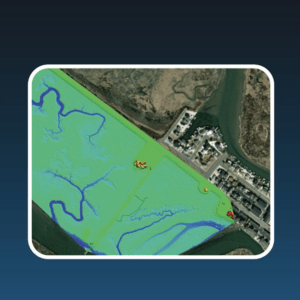
Correlator3D streamlines image processing for the Joint Airborne Lidar Bathymetry Technical Center of Expertise, enhancing topo-bathy lidar mapping efficiency. by DRONELIFE Staff Writer Ian J. McNabb SimActive Inc. recently announced that their Correlator3D product was deployed by the US Army Corps of Engineers for corridor mapping. The software is used to … [Read more...] about US Army Corps of Engineers Deploys SimActive’s Correlator3D for Coastal Corridor Mapping
LiDAR mapping
Drone Policy Shifts, Counter-UAS Tech and Market Disruptions on Weekly Wings

In this episode of Weekly Wings, Paul Rossi and Terry Neff break down the latest financial and policy shifts impacting the drone industry. They discuss how recent political and economic changes are driving acquisitions and vertical integration within the U.S. drone sector, highlighting how companies like Unusual Machines are expanding their footprint with strategic … [Read more...] about Drone Policy Shifts, Counter-UAS Tech and Market Disruptions on Weekly Wings
Mastering Drone Mapping: Expert Tips for Success from SimActive’s Eric Andelin

SimActive and Correlator3D™: A Closer Look Drone mapping has transformed industries by making geospatial data more accessible. However, achieving high-quality results requires both the right tools and the right approach. DRONELIFE.com interviewed Eric Andelin, Senior Workflow Specialist at SimActive, to uncover actionable tips for drone operators. SimActive, a leader in … [Read more...] about Mastering Drone Mapping: Expert Tips for Success from SimActive’s Eric Andelin
Drone-Based LiDAR for Explosive Ordnance Disposal Units: More than Mapping
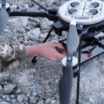
Drone-based LiDAR systems are being used by Explosive Ordnance Disposal (EOD) technicians for 3D mapping, in a successful transfer of technology from DoD laboratories to the field. "RedTail LiDAR Systems, a leader in microelectromechanical systems (MEMS) mirror-based light detection and ranging (LiDAR) technology, has delivered six LiDAR systems to the 707th Ordnance Company … [Read more...] about Drone-Based LiDAR for Explosive Ordnance Disposal Units: More than Mapping


