
Next-gen reconstruction tech delivers faster, more accurate 3D modeling for large-scale and complex environments DJI Terra: A Powerful Tool for Aerial Data Processing DJI has expanded the capabilities of its Terra 3D modeling software with new reconstruction technologies, including 3D Gaussian Splatting. DJI Terra is designed to create accurate and detailed 2D and 3D models … [Read more...] about DJI Terra 3D Modeling Software Now with 3D Gaussian Splatting – What’s That?
Featured - Surveying
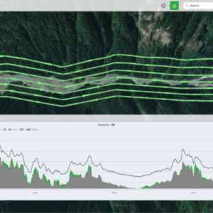
Wingtra Unveils WingtraRAY: A New Drone to Transform Aerial Surveying

The new platform offers faster workflows, safer urban operations, and broad payload flexibility for surveyors worldwide. Wingtra's new drone, WingtraRAY, designed to push the limits of aerial surveying and mapping. The WingtraRAY is built specifically for surveyors and promises to remove many of the operational barriers they face today. One major highlight is its ability to … [Read more...] about Wingtra Unveils WingtraRAY: A New Drone to Transform Aerial Surveying
The Engineering Behind UgCS: Insights from Kristaps Brass on the Future of Drone Flight Planning
Drone technology is evolving at a rapid pace, and with it comes the need for more advanced, reliable, and user-friendly flight planning software. At the forefront of this innovation is UgCS, developed by SPH Engineering. To gain a deeper understanding of the engineering challenges and breakthroughs behind UgCS, we interviewed Kristaps Brass, the company’s Product Owner and an … [Read more...] about The Engineering Behind UgCS: Insights from Kristaps Brass on the Future of Drone Flight Planning
Are RTK Modules a cyber weak spot for Drones? Sure hope not.
Examining the Cybersecurity Risks and Resilience of RTK Modules in Drone Navigation Systems by DRONELIFE Contributor T. Seth Ford (Drone615, Nashville, TN) Understanding the GPS and Space Economy Framework According to GPS.gov, the official website for government information concerning the United States’ Global Positioning System (GPS), it is comprised of three segments: the … [Read more...] about Are RTK Modules a cyber weak spot for Drones? Sure hope not.
Photogrammetry vs. LiDAR: Choosing the Right Tool for the Job, with Dr. Philippe Simard

SimActive Inc. has played a pivotal role in the evolution of geospatial data processing since its founding in 2003. Leading the company is Dr. Philippe Simard, a pioneer in the industry with a doctorate in electrical engineering from McGill University, specializing in computer vision. Under Dr. Simard’s leadership, SimActive’s flagship software, Correlator3D™, has become a … [Read more...] about Photogrammetry vs. LiDAR: Choosing the Right Tool for the Job, with Dr. Philippe Simard


