
Next-gen reconstruction tech delivers faster, more accurate 3D modeling for large-scale and complex environments DJI Terra: A Powerful Tool for Aerial Data Processing DJI has expanded the capabilities of its Terra 3D modeling software with new reconstruction technologies, including 3D Gaussian Splatting. DJI Terra is designed to create accurate and detailed 2D and 3D models … [Read more...] about DJI Terra 3D Modeling Software Now with 3D Gaussian Splatting – What’s That?
drone photogrammetry
Drone Mapping Transforms Police Crash Investigations: A Blue Marble Geographics Case Study

Drones are rapidly becoming indispensable tools for law enforcement, not only for real-time situational awareness and Drone as First Responder (DFR) programs, but also for post-incident documentation and analysis. A recent case study from Blue Marble Geographics, featuring the Windham, Maine Police Department, illustrates how drone mapping is revolutionizing crash … [Read more...] about Drone Mapping Transforms Police Crash Investigations: A Blue Marble Geographics Case Study
SPH Engineering Unveils Circlegrammetry: A New Approach to Drone Photogrammetry
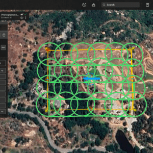
New tool promises faster, more accurate 3D models with shorter flight times SPH Engineering has introduced Circlegrammetry, a new photogrammetry tool that could change how drone operators capture data for 3D modeling and mapping. Designed in response to challenges faced by drone pilots, Circlegrammetry aims to improve the accuracy, speed, and efficiency of aerial mapping … [Read more...] about SPH Engineering Unveils Circlegrammetry: A New Approach to Drone Photogrammetry
Mapping and LiDAR: SimActive Integrated with LiDAR Solution for Drones

Drone-based mapping and LiDAR are a powerful combination. Now, Canada's SimActive Inc., a leading developer of photogrammetry software that can accommodate aerial imagery from satellite, manned aircraft, or drones, announces the integration of its Correlator3D™ product into LiDAR systems for drones developed by LiDAR USA. LiDARUSA, also known as Fagerman Technologies, is a … [Read more...] about Mapping and LiDAR: SimActive Integrated with LiDAR Solution for Drones
Delair Introduces New LiDAR Drone with New Industry Firsts

Delair has been an industry leader for industrial drone solutions for a number of years now - and today they've announced the next generation of high-performance industrial drones with the Delair DT26X LiDAR UAV. It's the first fixed-wing to carry the sophisticated RIEGL LiDAR sensor. Founded in France, Delair has had the advantage of legally flying beyond visual line of … [Read more...] about Delair Introduces New LiDAR Drone with New Industry Firsts


