• Skip to main content
  • Skip to secondary menu
  • Skip to primary sidebar
  • Skip to secondary sidebar
  • Skip to footer
  • DroneRacingLife
  • DroneFlyers
  • Newsletter
DroneLife

DRONELIFE

Stay up to date on all the latest Drone News

  • News
  • Products
  • Industries
    • Agriculture
    • Construction
    • Delivery
    • Dual Use
    • Inspection
    • Public Safety
    • Surveying
  • Enthusiasts
  • Regulations
  • Business
  • Video
  • Podcasts

SimActive Photogrammetry Software: Enabling Users to Meet Accuracy Standards for Over 20 Years

April 7, 2024 by Miriam McNabb 13 Comments

Mastering Precision: Navigating the Evolving Landscape of Photogrammetry with SimActive

SimActive, a Montreal-based photogrammetry software company with over 20 years serving the mapping community. From satellites to aircraft and drones, one software for all acquisition platforms, designed to support all sizes of professional photogrammetry providers.

Accuracy standards are crucial in promoting consistency, reliability, and quality in the geospatial data we deliver. However, these standards may vary based on local governing bodies, municipalities, governmental departments and so on. Additionally, as technology improves, these standards may occasionally change.

Ultimately, it comes down to the end-user the data are captured and delivered to, but they often themselves may need to be educated as well. This is where the data provider becomes the facilitator in the process. Knowing what kind of resolution and accuracy can be provided with the tools available, conveying that information to the customer and assisting in them determining what they may need.

One of the biggest challenges today is the anxiousness of new entrants into the mapping business, especially with drones to oversell technology as a differentiator. Flying lower, with a higher resolution camera does not necessarily correlate to higher accuracy. Neither does a drone with a RTK or PPK solution if not coupled with a highly accurate/ military grade IMU.

Every project should include ground survey, without it there is no way to establish and validate high-accuracy mapping deliverables. If no one is available in-house to collect GCPs, then a local surveyor should be hired. Having surveyors collect additional GCP’s will always be cheaper than having to re-mobilize and potentially re-fly because not enough was collected initially.

Photogrammetry Accuracy StandardsUnderstanding the principles of photogrammetry is much more important than technology. Acquisition plans should exceed project boundaries, as variations in terrain will affect overlap and should be considered. GCP’s should be distributed throughout the project with the assumption that there is no RTK/PPK in the drone being used in case it fails. Flying lower is not necessarily beneficial as it creates many more images for processing and much larger files to deliver, not to mention potential incursions with radio antenna, power lines, or even the ground.

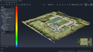
Once the imagery is captured, and GCP’s are available, higher-end photogrammetry software such as SimActive’s Correlator3D can be used to create and validate mapping deliverables. Quality reports generated during aerial triangulation, users can determine if the mapping deliverables meet the client’s accuracy requirements, share this information with them or reformat the results into an accuracy report/statement of their choosing.

More information on meeting accuracy standards can be found here.

Read more:

  • Enhancing Photogrammetry Accuracy with Advanced GCPs Integration by SimActive and CompassData
  • Revolutionizing 3D Mapping: SimActive’s Integration with Multi-Camera Drone Payloads
  • SimActive Enhances Cloud Productivity with Correlator3D Upgrade
  • SimActive Releases New Version of Correlator 3D: Point Clouds and DSMs, Generated Twice as Fast


Miriam McNabb

Miriam McNabb is the Editor-in-Chief of DRONELIFE and CEO of JobForDrones, a professional drone services marketplace, and a fascinated observer of the emerging drone industry and the regulatory environment for drones. Miriam has penned over 3,000 articles focused on the commercial drone space and is an international speaker and recognized figure in the industry.  Miriam has a degree from the University of Chicago and over 20 years of experience in high tech sales and marketing for new technologies.
For drone industry consulting or writing, Email Miriam.

TWITTER:@spaldingbarker

Subscribe to DroneLife here.

Filed Under: Applications, Drone News, Drone News Feeds, Featured, Featured - Surveying, News, Sponsored Content, Survey, Surveying Tagged With: accuracy validation methods, aerial survey accuracy, drone mapping technology, geospatial data reliability, ground control points, mapping accuracy, photogrammetry principles, photogrammetry software, professional mapping solutions, SimActive Correlator3D

Reader Interactions

Trackbacks

  1. SimActive Correlator3D Multi-Digicam Replace - DRONELIFE - Techbrusts says:
    April 20, 2024 at 10:08 am

    […] Correlator3D can assist fast manufacturing of enormous, complicated datasets. DroneLife lately reported on SimActive’s historical past of mapping software program, exploring their greater than 2 a long time of high-accuracy […]

    Reply
  2. SimActive Correlator3D Multi-Camera Update - DRONELIFE - Mdroid Games says:
    April 20, 2024 at 10:06 am

    […] and GPUs, Correlator3D can support rapid production of large, complex datasets. DroneLife recently reported on SimActive’s history of mapping software, exploring their more than 2 decades of high-accuracy […]

    Reply
  3. SimActive Correlator3D Multi-Digital camera Replace - DRONELIFE - My Blog says:
    April 18, 2024 at 10:36 am

    […] GPUs, Correlator3D can assist speedy manufacturing of enormous, advanced datasets. DroneLife lately reported on SimActive’s historical past of mapping software program, exploring their greater than 2 a long time of high-accuracy […]

    Reply
  4. SimActive Enhances Correlator3D with Multi-Camera System Compatibility - Worldnews4 says:
    April 18, 2024 at 5:06 am

    […] and GPUs, Correlator3D can support rapid production of large, complex datasets. DroneLife recently reported on SimActive’s history of mapping software, exploring their more than 2 decades of high-accuracy […]

    Reply
  5. SimActive Correlator3D Multi-Camera Update – DRONELIFE – PinSystem says:
    April 17, 2024 at 3:23 pm

    […] and GPUs, Correlator3D can support rapid production of large, complex datasets. DroneLife recently reported on SimActive’s history of mapping software, exploring their more than 2 decades of high-accuracy […]

    Reply
  6. SimActive Correlator3D Multi-Camera Update - DRONELIFE - Newest Tech Trends says:
    April 17, 2024 at 2:07 pm

    […] and GPUs, Correlator3D can support rapid production of large, complex datasets. DroneLife recently reported on SimActive’s history of mapping software, exploring their more than 2 decades of high-accuracy […]

    Reply
  7. SimActive Correlator3D Multi-Digicam Replace - DRONELIFE - 3DCOR says:
    April 17, 2024 at 7:33 am

    […] GPUs, Correlator3D can help fast manufacturing of huge, complicated datasets. DroneLife just lately reported on SimActive’s historical past of mapping software program, exploring their greater than 2 many years of high-accuracy […]

    Reply
  8. SimActive Correlator3D Multi-Digicam Replace - DRONELIFE - Exigise says:
    April 17, 2024 at 5:31 am

    […] Correlator3D can help speedy manufacturing of huge, advanced datasets. DroneLife not too long ago reported on SimActive’s historical past of mapping software program, exploring their greater than 2 many years of high-accuracy […]

    Reply
  9. Mise à jour multi-caméras SimActive Correlator3D - DRONELIFE - DroidTuto.com says:
    April 17, 2024 at 5:29 am

    […] la production rapide d’ensembles de données volumineux et complexes. DroneLife récemment a rendu compte de l’histoire du logiciel de cartographie de SimActiveexplorant leurs plus de deux décennies de suivi de haute […]

    Reply
  10. SimActive Photogrammetry Software: Enabling Users to Meet Accuracy Standards for over 20 years - Worldnews4 says:
    April 8, 2024 at 12:06 am

    […] Miriam McNabb is the Editor-in-Chief of DRONELIFE and CEO of JobForDrones, a professional drone services marketplace, and a fascinated observer of the emerging drone industry and the regulatory environment for drones. Miriam has penned over 3,000 articles focused on the commercial drone space and is an international speaker and recognized figure in the industry.  Miriam has a degree from the University of Chicago and over 20 years of experience in high tech sales and marketing for new technologies.For drone industry consulting or writing, Email Miriam. […]

    Reply
  11. simactive-photogrammetry-software accuracy-standards - DRONELIFE - Drone Stuff Pro says:
    April 7, 2024 at 9:10 pm

    […] Supply hyperlink asubhan wordpress autoblog amazon autoblog affiliate autoblog wordpress web site web site growth […]

    Reply
  12. simactive-photogrammetry-software accuracy-standards – DRONELIFE – drone-app.com says:
    April 7, 2024 at 8:20 pm

    […] Supply hyperlink […]

    Reply
  13. SimActive Photogrammetry Software: Enabling Users to Meet Accuracy Standards for over 20 years – Independent Drone Exchange says:
    April 7, 2024 at 5:56 pm

    […] post SimActive Photogrammetry Software: Enabling Users to Meet Accuracy Standards for over 20 years appeared first on […]

    Reply

Leave a Reply Cancel reply

Your email address will not be published. Required fields are marked *

Primary Sidebar

LATEST

DroneDeploy Launches Progress AI to Automate Construction Tracking

New AI tool delivers accurate jobsite updates in minutes, saving time and reducing risk DroneDeploy Introduces AI-Powered Construction Progress Tool…

Continue Reading DroneDeploy Launches Progress AI to Automate Construction Tracking

Hands-On Learning, Public Safety Take Center Stage at Commercial UAV Expo 2025

Partnerships with Pilot Institute and AIRT Bring Comprehensive Training for Drone Pilots and First Responders The Commercial UAV Expo 2025…

Continue Reading Hands-On Learning, Public Safety Take Center Stage at Commercial UAV Expo 2025

Blueflite Drones to Deliver Auto Parts in Detroit

Michigan-Backed Pilot Project Aims to Modernize Automotive Logistics with Aerial Delivery A New Era of Auto Parts Delivery In a…

Continue Reading Blueflite Drones to Deliver Auto Parts in Detroit

Amprius Delivers Next-Gen SiCore® Batteries to Leading Drone Manufacturers

High-energy cells support long-endurance UAV missions for Airbus subsidiary AALTO and others Amprius Expands Drone Battery Shipments from Fremont Pilot…

Continue Reading Amprius Delivers Next-Gen SiCore® Batteries to Leading Drone Manufacturers

Solid State Batteries: A Disruptive Force in the Commercial and Dual-Use Drone Market

Battery Endurance: The Persistent Drone Challenge Battery life has long stood as a defining constraint in commercial and dual-use drone…

Continue Reading Solid State Batteries: A Disruptive Force in the Commercial and Dual-Use Drone Market

Drones Join the Front Lines in Deadly Texas Flood Response

Group deploys drones to search for victims in Texas Hill Country flood By DRONELIFE Features Editor Jim Magill The deadly…

Continue Reading Drones Join the Front Lines in Deadly Texas Flood Response

Tethered and Unstoppable: How Fiber-Optic Drones Are Rewriting the Rules of Battlefield Control

As radio-controlled drones face growing interference, Ukraine and Russia embrace fiber-optic UAVs for unjammable, high-precision operations. What Is a Fiber-Optic…

Continue Reading Tethered and Unstoppable: How Fiber-Optic Drones Are Rewriting the Rules of Battlefield Control

U.S. Drone Industry Investment Surges Amid Sweeping Legislative Reforms

The drone industry in the United States is experiencing a surge in investment and capital flow, as a series of…

Continue Reading U.S. Drone Industry Investment Surges Amid Sweeping Legislative Reforms

US and Ukraine Move Closer to Landmark Drone Deal

Big Plans for Drone Collaboration The United States and Ukraine are in advanced talks over a new partnership that could…

Continue Reading US and Ukraine Move Closer to Landmark Drone Deal

High Lander Launches Vega HighSite for Local Airspace Management

New solution enables safe and scalable drone operations for commercial and government sites High Lander Aviation has introduced Vega HighSite,…

Continue Reading High Lander Launches Vega HighSite for Local Airspace Management

Secondary Sidebar

Footer

SPONSORED

Inspired Flight Gremsy IF800 VIO F1 drones geo week

What Will It Take to Strengthen U.S. Drone Manufacturing? A Conversation with Inspired Flight’s CEO

Global Mapper Mobile data collection

Collection Ground Control Points with Global Mapper Mobile

Military Drone Mapping Solutions

How SimActive’s Correlator3D™ is Revolutionizing Military Mapping: An Exclusive Interview with CEO Philippe Simard

NACT Engineering Parrot ANAFI tether indoor shot

Smart Tether for Parrot ANAFI USA from NACT Engineering

Blue Marble, features global mapper, features Blue Marble

Check Out These New Features in Global Mapper v25 from Blue Marble

Blue Marble Graphics, Blue Marble Mobile Mapper

Global Mapper Mobile: Streamlining Data Collection and Processing

About Us | Contact Us | Advertise With Us | Write for Us | Privacy Policy | Terms of Service

The Trusted Source for the Business of Drones.

This website uses cookies and third party services. By clicking OK, you are agreeing to our privacy policy. ACCEPT

Manage consent

Privacy Overview

This website uses cookies to improve your experience while you navigate through the website. Out of these, the cookies that are categorized as necessary are stored on your browser as they are essential for the working of basic functionalities of the website. We also use third-party cookies that help us analyze and understand how you use this website. These cookies will be stored in your browser only with your consent. You also have the option to opt-out of these cookies. But opting out of some of these cookies may affect your browsing experience.
Necessary
Always Enabled
Necessary cookies are absolutely essential for the website to function properly. These cookies ensure basic functionalities and security features of the website, anonymously.
CookieDurationDescription
cookielawinfo-checkbox-analytics11 monthsThis cookie is set by GDPR Cookie Consent plugin. The cookie is used to store the user consent for the cookies in the category "Analytics".
cookielawinfo-checkbox-functional11 monthsThe cookie is set by GDPR cookie consent to record the user consent for the cookies in the category "Functional".
cookielawinfo-checkbox-necessary11 monthsThis cookie is set by GDPR Cookie Consent plugin. The cookies is used to store the user consent for the cookies in the category "Necessary".
cookielawinfo-checkbox-others11 monthsThis cookie is set by GDPR Cookie Consent plugin. The cookie is used to store the user consent for the cookies in the category "Other.
cookielawinfo-checkbox-performance11 monthsThis cookie is set by GDPR Cookie Consent plugin. The cookie is used to store the user consent for the cookies in the category "Performance".
viewed_cookie_policy11 monthsThe cookie is set by the GDPR Cookie Consent plugin and is used to store whether or not user has consented to the use of cookies. It does not store any personal data.
Functional
Functional cookies help to perform certain functionalities like sharing the content of the website on social media platforms, collect feedbacks, and other third-party features.
Performance
Performance cookies are used to understand and analyze the key performance indexes of the website which helps in delivering a better user experience for the visitors.
Analytics
Analytical cookies are used to understand how visitors interact with the website. These cookies help provide information on metrics the number of visitors, bounce rate, traffic source, etc.
Advertisement
Advertisement cookies are used to provide visitors with relevant ads and marketing campaigns. These cookies track visitors across websites and collect information to provide customized ads.
Others
Other uncategorized cookies are those that are being analyzed and have not been classified into a category as yet.
SAVE & ACCEPT