• Skip to main content
  • Skip to secondary menu
  • Skip to primary sidebar
  • Skip to secondary sidebar
  • Skip to footer
  • DroneRacingLife
  • DroneFlyers
  • Newsletter
DroneLife

DRONELIFE

Stay up to date on all the latest Drone News

  • News
  • Products
  • Industries
    • Agriculture
    • Construction
    • Delivery
    • Dual Use
    • Inspection
    • Public Safety
    • Surveying
  • Enthusiasts
  • Regulations
  • Business
  • Video
  • Podcasts

North Carolina Drone Operator to Seek Further Review in First Amendment Lawsuit

May 21, 2024 by Miriam McNabb 4 Comments

Appeals Court Upholds Ban on Aerial Mapping by Non-Surveyors

A three-judge panel of the 4th U.S. Circuit Court of Appeals has ruled that North Carolina can prohibit the creation of aerial maps by anyone other than licensed land surveyors. This decision affects Michael Jones, a drone operator based in Goldsboro, North Carolina, as well as other entrepreneurs in the state. Jones, along with the Institute for Justice (IJ), plans to seek further appellate review to restore his right to provide aerial mapping services without government interference.

North Carolina’s land-surveying board has been targeting small drone operators, claiming their maps and models constitute illegal “surveying.” Unlike many other states, North Carolina classifies even basic aerial mapping as “surveying,” requiring a full surveyor’s license. This license demands years of education and experience. The surveying board has enforced this law strictly, threatening drone companies with civil and criminal penalties.

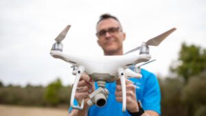
Jones, an FAA-licensed drone operator and photographer, aimed to start an aerial-mapping business to offer landowners a bird’s-eye view of their property, useful in situations where a full land survey is unnecessary. However, in 2019, the surveying board issued a cease-and-desist letter to Jones, demanding he stop his mapping operations or face severe penalties.

IJ Attorney James Knight stated, “The court’s decision today injects uncertainty into a basic question of First Amendment law: How do we determine when speech is speech? Today’s ruling says that the state can criminalize sharing certain types of photos without a government-issued license. And it does so on the theory that such a law somehow does not regulate ‘speech.’ The ruling is badly flawed: Photographs are speech.”

Jones sued the board, arguing that creating and sharing visual information about land is free speech protected by the Constitution. The Fourth Circuit, however, determined that Jones’s actions do not constitute speech, but rather “conduct” that falls under the surveying profession. The court also reasoned that because Jones’s activities take place on private property, the government has more leeway to regulate them than if they occurred on public land.

The decision allows North Carolina to enforce its law without considering its impact on free speech rights, putting Jones and other drone photographers at risk.

“Drone technology may be new, but the principles at stake in Michael’s case are as old as the nation itself,” said IJ Senior Attorney Sam Gedge. “Taking photos and providing information to willing clients is speech, and it’s fully protected by the First Amendment. Only by badly misapplying the First Amendment could the Fourth Circuit hold differently.”

Jones and his company, 360 Virtual Drone Services LLC, will seek further review, either from the full Fourth Circuit or the U.S. Supreme Court.

“When the surveying board first told me that I was breaking the law, I could hardly believe it,” said Jones. “I didn’t think that I was doing anything that could be considered surveying. In fact, I don’t know of any surveying company that was using drones like I was. I’m looking to keeping up the fight and getting justice, not just for myself, but for other drone operators across North Carolina.”

The Institute for Justice defends First Amendment rights and economic liberty nationwide. In December 2020, IJ successfully defended a Mississippi mapping company similarly charged with unlicensed practice. IJ has also won appeals court decisions in free speech cases for a veterinarian in Texas and tour guides in Charleston, South Carolina.  Find more information on the case here.

Read more:

  • Is Drone Mapping a First Amendment Right? This NC Lawsuit Has Major Implications for the Commercial Drone Industry
  • Surveyors Wanted to Shut this Drone Photographer Down. Now, He’s Fighting Back. [VIDEO]
  • Drone Surveillance Case Goes to Michigan Supreme Court
Miriam McNabb

Miriam McNabb is the Editor-in-Chief of DRONELIFE and CEO of JobForDrones, a professional drone services marketplace, and a fascinated observer of the emerging drone industry and the regulatory environment for drones. Miriam has penned over 3,000 articles focused on the commercial drone space and is an international speaker and recognized figure in the industry.  Miriam has a degree from the University of Chicago and over 20 years of experience in high tech sales and marketing for new technologies.
For drone industry consulting or writing, Email Miriam.

TWITTER:@spaldingbarker

Subscribe to DroneLife here.

Filed Under: Drone News, Drone News Feeds, Drones in the News, Featured - Surveying, News, Surveying Tagged With: aerial mapping lawsuit, aerial photography legal case, drone mapping business, drone operator lawsuit, FAA-licensed drone operator, first amendment rights, free speech protection, Institute for Justice, land surveying regulations, North Carolina drone mapping

Reader Interactions

Comments

  1. Larry says

    April 10, 2025 at 6:49 pm

    Why stop there . politicians go after drone operators.
    Every time a politician makes a rule they go after the people who have licenses follow the laws. That’s why it never works.

    Legal operators are also photographers. They forget that part they don’t care about aunt Millie and a bathing suit.

    Why stop there? Why don’t they go after everybody had to have a iphone camera ? take photo in public should be fined $100. I don’t want no cameras in public buildings where I go. I don’t want my photo taken. I don’t want cameras on the road I don’t want no street cameras it’s different for them. if it’s good for one is good for all .get rid of all the cameras go back into the early ages go backwards

    They think every photo someone takes s a conspiracy
    That person is photographing my house without my permission
    WRONG Chinese don’t care about your drone photo
    (All they gotta do is look at Google Earth), really

    .

    Reply
    • Angela Choma-Burgaj says

      May 17, 2025 at 11:25 am

      I think that the laws are fair and people who misjudge people who follow the laws are assholes

      Reply

Trackbacks

  1. North Carolina Drone Mapping First Modification Case – drone-app.com says:
    May 21, 2024 at 5:52 pm

    […] Supply hyperlink […]

    Reply
  2. North Carolina Drone Operator to Seek Further Review in First Amendment Lawsuit – Independent Drone Exchange says:
    May 21, 2024 at 12:52 pm

    […] post North Carolina Drone Operator to Seek Further Review in First Amendment Lawsuit appeared first on […]

    Reply

Leave a Reply Cancel reply

Your email address will not be published. Required fields are marked *

Primary Sidebar

LATEST

DroneDeploy Launches Progress AI to Automate Construction Tracking

New AI tool delivers accurate jobsite updates in minutes, saving time and reducing risk DroneDeploy Introduces AI-Powered Construction Progress Tool…

Continue Reading DroneDeploy Launches Progress AI to Automate Construction Tracking

Hands-On Learning, Public Safety Take Center Stage at Commercial UAV Expo 2025

Partnerships with Pilot Institute and AIRT Bring Comprehensive Training for Drone Pilots and First Responders The Commercial UAV Expo 2025…

Continue Reading Hands-On Learning, Public Safety Take Center Stage at Commercial UAV Expo 2025

Blueflite Drones to Deliver Auto Parts in Detroit

Michigan-Backed Pilot Project Aims to Modernize Automotive Logistics with Aerial Delivery A New Era of Auto Parts Delivery In a…

Continue Reading Blueflite Drones to Deliver Auto Parts in Detroit

Amprius Delivers Next-Gen SiCore® Batteries to Leading Drone Manufacturers

High-energy cells support long-endurance UAV missions for Airbus subsidiary AALTO and others Amprius Expands Drone Battery Shipments from Fremont Pilot…

Continue Reading Amprius Delivers Next-Gen SiCore® Batteries to Leading Drone Manufacturers

Solid State Batteries: A Disruptive Force in the Commercial and Dual-Use Drone Market

Battery Endurance: The Persistent Drone Challenge Battery life has long stood as a defining constraint in commercial and dual-use drone…

Continue Reading Solid State Batteries: A Disruptive Force in the Commercial and Dual-Use Drone Market

Drones Join the Front Lines in Deadly Texas Flood Response

Group deploys drones to search for victims in Texas Hill Country flood By DRONELIFE Features Editor Jim Magill The deadly…

Continue Reading Drones Join the Front Lines in Deadly Texas Flood Response

Tethered and Unstoppable: How Fiber-Optic Drones Are Rewriting the Rules of Battlefield Control

As radio-controlled drones face growing interference, Ukraine and Russia embrace fiber-optic UAVs for unjammable, high-precision operations. What Is a Fiber-Optic…

Continue Reading Tethered and Unstoppable: How Fiber-Optic Drones Are Rewriting the Rules of Battlefield Control

U.S. Drone Industry Investment Surges Amid Sweeping Legislative Reforms

The drone industry in the United States is experiencing a surge in investment and capital flow, as a series of…

Continue Reading U.S. Drone Industry Investment Surges Amid Sweeping Legislative Reforms

US and Ukraine Move Closer to Landmark Drone Deal

Big Plans for Drone Collaboration The United States and Ukraine are in advanced talks over a new partnership that could…

Continue Reading US and Ukraine Move Closer to Landmark Drone Deal

High Lander Launches Vega HighSite for Local Airspace Management

New solution enables safe and scalable drone operations for commercial and government sites High Lander Aviation has introduced Vega HighSite,…

Continue Reading High Lander Launches Vega HighSite for Local Airspace Management

Secondary Sidebar

Footer

SPONSORED

Inspired Flight Gremsy IF800 VIO F1 drones geo week

What Will It Take to Strengthen U.S. Drone Manufacturing? A Conversation with Inspired Flight’s CEO

Global Mapper Mobile data collection

Collection Ground Control Points with Global Mapper Mobile

Military Drone Mapping Solutions

How SimActive’s Correlator3D™ is Revolutionizing Military Mapping: An Exclusive Interview with CEO Philippe Simard

Photogrammetry Accuracy Standards

SimActive Photogrammetry Software: Enabling Users to Meet Accuracy Standards for Over 20 Years

NACT Engineering Parrot ANAFI tether indoor shot

Smart Tether for Parrot ANAFI USA from NACT Engineering

Blue Marble, features global mapper, features Blue Marble

Check Out These New Features in Global Mapper v25 from Blue Marble

About Us | Contact Us | Advertise With Us | Write for Us | Privacy Policy | Terms of Service

The Trusted Source for the Business of Drones.

This website uses cookies and third party services. By clicking OK, you are agreeing to our privacy policy. ACCEPT

Manage consent

Privacy Overview

This website uses cookies to improve your experience while you navigate through the website. Out of these, the cookies that are categorized as necessary are stored on your browser as they are essential for the working of basic functionalities of the website. We also use third-party cookies that help us analyze and understand how you use this website. These cookies will be stored in your browser only with your consent. You also have the option to opt-out of these cookies. But opting out of some of these cookies may affect your browsing experience.
Necessary
Always Enabled
Necessary cookies are absolutely essential for the website to function properly. These cookies ensure basic functionalities and security features of the website, anonymously.
CookieDurationDescription
cookielawinfo-checkbox-analytics11 monthsThis cookie is set by GDPR Cookie Consent plugin. The cookie is used to store the user consent for the cookies in the category "Analytics".
cookielawinfo-checkbox-functional11 monthsThe cookie is set by GDPR cookie consent to record the user consent for the cookies in the category "Functional".
cookielawinfo-checkbox-necessary11 monthsThis cookie is set by GDPR Cookie Consent plugin. The cookies is used to store the user consent for the cookies in the category "Necessary".
cookielawinfo-checkbox-others11 monthsThis cookie is set by GDPR Cookie Consent plugin. The cookie is used to store the user consent for the cookies in the category "Other.
cookielawinfo-checkbox-performance11 monthsThis cookie is set by GDPR Cookie Consent plugin. The cookie is used to store the user consent for the cookies in the category "Performance".
viewed_cookie_policy11 monthsThe cookie is set by the GDPR Cookie Consent plugin and is used to store whether or not user has consented to the use of cookies. It does not store any personal data.
Functional
Functional cookies help to perform certain functionalities like sharing the content of the website on social media platforms, collect feedbacks, and other third-party features.
Performance
Performance cookies are used to understand and analyze the key performance indexes of the website which helps in delivering a better user experience for the visitors.
Analytics
Analytical cookies are used to understand how visitors interact with the website. These cookies help provide information on metrics the number of visitors, bounce rate, traffic source, etc.
Advertisement
Advertisement cookies are used to provide visitors with relevant ads and marketing campaigns. These cookies track visitors across websites and collect information to provide customized ads.
Others
Other uncategorized cookies are those that are being analyzed and have not been classified into a category as yet.
SAVE & ACCEPT